I discovered D.C. from its sidewalks, paths, and trails. It is a runner's paradise; or at least, I remember it as such because it was here that I transformed from a person running to stay active, into a person that ran fast and far for its own sake. I may not be the best person to ask for restaurant advice, or the best to tell you where to tell you where to get a new hairdo, but I do know D.C.'s best running spots like the back of my hand. And here they are, in approximate order of awesomeness:
- The Glover-Archibald trail
- The Melvin C. Hazen trail
- Rock Creek Parkway path
- C&O Canal trail
- Rock Creek extension and the National Mall
- Mt. Vernon Trail
- Hains Point
- Northern Rock Creek
Plus, Jamie's 15-mile Extravaganza. And, as an afterthought, I've also included a cross-training guide with a brief overview of the D.C.
pools and
gyms I've utilized during my time here (which were many despite my relatively brief engagement).
- Glover-Archibald trail: The finest single track in town

Where: The Glover-Archibald trail heads south from near the intersection of Wis consin Ave. and Van Ness St. and runs all the way to the Georgetown campus. To find the trail head, go about 100 yards east along Van Ness St. from the intersection and turn into the small park on your left. A faint single track extends from the small road alongside McDonald's all the way in to the woods. Alternatively, from the Canal Road entrance to Georgetown head east along Canal Road until a weed-ridden break in the trees with a rusted rail road tressel about thirty yards back from the road. With a little trust in this blog, run north into the woods. You may want to run this going south the first time heading as its path is a little more obvious coming from Van Ness.
Why I love it: This trail is long, challenging, beautiful, quiet, and exciting. As the well worn trail drops down from Van Ness it keeps you thinking: about clearing roots, staying in control at a sprint on downhill sections, which rocks will get you across small streams, how nice the woods are in summer, and so on. The trail is also clean, e.g. free of the plastic bags, broken bottles, and syringes that litter Rock Creek's southern single track trails. It twists and turns for over 2.5 miles with only five easy road crossings and connects you to other great routes: the C&O Canal, Rock Creek, and the Key Bridge to Arlington in the southern end; and Connecticut Road and the Melvin C. Hazen trail in the northern extreme.
Distance: 2.7 miles, approximately
Elevation: severe
Recommended loop: Head down the entirety of the Glover-Archibald trail until it hits Canal Road in Georgetown. Go through the tunnel (see C&O section below) and head east along the trail; climb the wooden steps that come along shortly to run through Georgetown alongside the C&O Canal. When you hit Rock Creek Parkway run north along the parkway, past Woodley Park, past the zoo, all the way to Melvin C. Hazen park near the intersection of Tilden St. and Beach Drive (the extension of the parkway) Find the Melvin C. Hazen trail tucked away to your left, and head up the ravine, over Connecticutt, through the apartment parking lot, to the intersection of Tilden and Reno. Head up Reno a bit to Van Ness and turn left (east). Go east a few blocks along Van Ness and over Wisconsin to finish an incredible loop. You can pick this loop up from Woodley Park, Van Ness, Georgetown, Dupont (via P Street), or Glover Park.
Distance: 9 miles, approximately;
Elevation: severe (by D.C. standards)
- The Melvin C. Hazen trail: A nearby extension of the best single track in town
Where: This trail heads southwest from the intersection of Tilden St. and Reno St. in Van Ness, crosses Connecticut, and finishes in the Melvin C. Hazen Park in Rock Creek, between Van Ness and Mount Pleasant. You can also pick it up where it crosses Connecticut just south of Sedgwick St. On the eastern side of Connecticut it disappears down a hill into the woods; on the western side of the street you'll find the other trail head hidden in a parking lot behind an apartment building just across the street from the other continuation of the trail. It can be overgrown in the summer, but look to the far side of the parking lot for some wooden railroad tie-stairs that begin the trail.
Why I love it: This trail is great for the same reasons as the Glover-Archibald trail, and together they make a great long run.
Distance: .9 miles, approximately
Elevation: severe
Recommended loop: See above, or for a shorter loop, from the trail's crossing with Connecticut Ave. head southeast down the hill. Once you hit the actual Melvin C. Hazen Park, jaunt north to nearby Tilden St. and head left (west) along Tilden, up a challenging hill to intersect Connecticut. Cross Connecticut and continue along Tilden. Find the northern head of the Melvin Hazen trail on your left near Tilden's intersection with Reno. Head down the trail until you climb some steps into the parking lot of an apartment building on Connecticut--right across the street from your starting point.
Distance: 1.8 miles;
Elevation: severe
- Rock Creek pathway: Nice despite the car exhaust
Why I love it: Rock Creek Parkway extends from the Potomac River near Georgetown all the way to Maryland. It could be cleaner, more scenic, and quieter, but the path itself is well paved and easy to access from many neighborhoods. It's a great connector for other trails too.
Distance: As far as you want
Elevation: The path constantly rises heading north, but there are only a few serious inclines
- C&O Canal trail: A blast from the past
Where: The C&O Canal parallels the Potomac River all the way to Harpers Ferry, WV, starting in Georgetown. The very first step of the trail breaks away from the Rock Creek Parkway path just south of Pennsylvania Ave. It starts as an inconspicuous brick path beside the canal, and turns into a wide dirt trail by the time you've hit the Key Bridge. As you head west get on the south side of the canal; the metal bridge south of Francis Scott Key Park is your last chance. Then continue west a bit and drop down the multiple flights of wooden stairs to reach the real trail that extends to Harpers Ferry. About a half-mile onward, notice that there's a creepy tunnel going under Canal Road--this puts your under the canal itself and onto the north side of the street, from which you can get back to Georgetown, or better yet, head a few steps west along Canal Road to access the Glover-Archibald trail's southern head (see above).
Why I love it: The short span of this trail between Rock Creek and Key Bridge makes for a scenic connection between Rock Creek and the Mt. Vernon trails for long runs. Beyond Georgetown it is quiet, and relatively empty, although you will have to be mindful of bikes that race along the paved first few miles. The canal is historically intriguing--it carried canal boats up the Potomac River, past Great Falls, and onward toward Pennsylvania.
Distance: As long as you want it to be
Elevation: Flat for vast stretches, with gentle rises over time in certain areas
Recommended loop: I love to incorporate the stretch of the canal in Georgetown into my runs, but rarely go beyond the Key Bridge because there aren't many loop possibilities.
- Rock Creek extension and The National Mall: Feel touristy
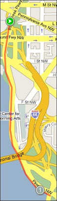 Where:
 It's obvious how to get to the Mall, but the Rock Creek extension I refer to begins in Georgetown and meets the Potomac near the Kennedy Center. It puts you right on the Mall at the Lincoln Memorial, from which you can also head to Hains Point.
Why I love it: Especially in my early Mr. Smith Goes to Washington-days, I enjoyed running along the Mall in sight of thought provoking monuments and remarkable architectal points of interest such as the Capitol, the National Museum of Art, and the White House. Even though the Potomac is rarely picturesque, the views into Arlington are good.
Distance: 1.2 miles from the C&O canal to the Lincoln Memorial, one way; 4 miles for a roundtrip of the Mall.
Elevation: No rise along the river, but some inclines around the Washington Monument and up onto the main Mall area
Recommended loop: You can make this its own loop from downtown, Capitol Hill, or Foggy Bottom. Otherwise, you can throw it into a longer loop that takes you along Rock Creek or into Virginia.
- Mt. Vernon Trail: The other side of the river
Where: Skirts the river in Arlington. It extends for miles all the way to Mt. Vernon south of town. North of Rosslyn it diverts from the river and follows I-66. Easy access points from D.C. are at the ends of Key Bridge and Memorial Bridge. It crosses Key Bridge at the first light in Virginia, and passes under Memorial Bridge--just do a 180 on the Virginia side of the bridge, following a short dirt footpath, across a traffic ramp, and onto the paved trail.
Why I love it: You may have to contend with a biker or two, but this is a nice scenic route that gets you out of the District for a change. It's also a great option if you want to put more distance between Georgetown and the Mall. Furthermore, it passes by Teddy Roosevelt Island, which I don't recommend for running, but is a nice place for shaded walks. The path is wide and well paved.
Distance: As long as you want it to be, but it's 1.25 miles along this between Key Bridge and Memorial Bridge
Elevation: Zero change
- Hains Point: Watch your footing
Where: South of the Tidal Basin and Jefferson Memorial. The path skirts East Potomac Park, a peninsula that parallels the D.C. harbor.
Why I love it: It's a nice, quiet paved walking/biking path along the water's edge. You may have to dodge a fisherman or two, but the other traffic is minimal. Otherwise, be cautious of sections where the cement is eroding into the river. If this bothers you, running along the road is just fine as vehicle traffic is minimal too. It's also a great route to run if you want to stop by the East Potomac Park Pool (see below).
Distance: 5.6 miles, starting and ending at the Lincoln Memorial
Elevation: Zero change
Recommended loop: This section can be thrown into a longer run along the Mall or Rock Creek Parkway. Even though Hains Point itself is all south of the Jefferson Memorial, I recommend including the portion along the Tidal Basic that heads past the FDR Memorial.
- Northern Rock Creek: Worth the trek
Where: Rock Creek Park, north of Tilden St./Beach Rd. and onward.
Why I love it: Honestly, I haven't run here much, but I enjoyed the few times I did. I can only point you to Ridge Road, an entire street that is reserved for walkers, runners, and bikers, that begins next to the old mills at the intersection of Tilden and Beach and continues north for a few miles. A number of unpaved trails shoot off of this artery, many of which seem great for running, but don't be surprised to run into a horse or two along the way.
Distance: Explore for miles
Elevation: It gets progressively hillier as travel north
18-mile ExtravaganzaOn longer days, I really enjoy throwing all of these together: starting arbitrarily in Van Ness, run down the Glover-Archibald Trail to Georgetown, cross the Key Bridge to Rosslyn, run south along the river to Memorial Bridge, throw in Hains Point if you're really feeling like a long day, down the Mall and back to the Lincoln Memorial to Rock Creek, up the park to the Melvin C. Hazen trail, and back to Van Ness. This killer loop is ____ with Hains Point, and ____ without. You can pick it up from Van Ness, Glover Park, Georgetown, Dupont via P Street, Mt. Pleasant, Rosslyn, Foggy Bottom, or anywhere else near the Mall.
A few notes on cross-trainingSwimmingI can't remember on the quality of other cities' public pools, but D.C.'s are more than adequate for swimming laps during the summer and winter months alike. There are plenty of swimming options in the summer--my favorite spots have been the Marie Reed Community Center pool in Adams Morgan (25-meter) which is open year-round, and the East Potomac Park pools on Hains Point (50-meter) open in the summer. Both are free to D.C. residents, strike me as clean, and offer locker and showering facilities (but bring your own lock). The East Potomac Park pool is an especially nice place to get a workout in while enjoying the sun on a warm summer's day. The two pools are never too crowded for those that don't mind sharing lanes with up to three other people.
For those willing to pay for their pools, I have similarly sampled D.C.'s fare. The National Capitol YMCA on 17th St. near Dupont Circle has a great 25-meter pool. I can't say that it's less crowded than the nearby Marie Reed Center's pool, but the facilities are nicer. Monthly rates are around $70 for the whole place (check the web for exact/current rates). A Washington Sports Club location recently opened in Columbia Heights that features a 25-yard pool. I have never used the pool, but took a tour of the location and was unimpressed. It appeared to be extremely shallow. Whereas the YMCA and public pools have deep-ends, this pool looked as if a tall person would have to watch their fingers on a crawl. In the end, I turned to Vida Fitness, with locations in Gallery Place and between Dupont and Logan Circles. Both locations feature Endless Pools, those recirculating pools you see in SkyMall magazine. I was skeptical at first, but I've been sold. NOTE: I am not a hardcore swimmer; I have never raced but for a few triathlons; and I don't have high standards as long as I can get space. I found that the moving stream of water really allowed me to focus on pacing and form, because rather than merely slowing down as one does in a real pool, you actually start moving backwards when you're falling behind your set pace (the machines are highly adjustable). Best of all, I have never had to wait for a machine--they are sparsely used by other gym-goers.
Gyms and MiscellaneousI don't care which gym you use--I think Vida is great because the equipment is new and plentiful, offering a strong mix of cardio, free and machine weights, yoga and fitness classes, and the Endless Pool--but I'm sure there are other good gyms. BUT, I will say, don't join the National Capital YMCA unless you A) don't care about free weights, B) really want a basketball court (but there's one of those at the new Washington Sports Club in Columbia Heights too), or C) can't wait to get back on a NordicTrack. The cardio is acceptable, but the free weight situation is deplorable. The machines are painfully old and creaky (perhaps unsafe), and terribly over populated. I can't tell you how many times I've just walked right back to the locker room after seeing how full the weight room was. YMCA needs to either do a better job controlling its membership, or it needs to prioritize more space for weights--perhaps over the three or so squash courts it has which cater to a much narrower clientelle. I joined for the pool, but didn't stick it out long. I'm sad to leave Vida behind in D.C.
Finally, although it's not a gym, If you're not too bashful to do the Muscle Beach-thing, head to the Rock Creek Parkour area just down the hill from Woodley Park. It features new pull up bars, benches and foot braces for situps and crunches, and a bunch of other silly things I don't use. It's a good stop to make if you're running by.


